
The Five Themes of Geography Made Easy: Your Step-by-Step Guide
Geography covers the globe. It’s one of the broadest subjects you’ll study. But understanding the five themes of geography gives you a practical framework that breaks down this complex field into concepts you can grasp.
The National Council for Geographic Education and the Association of American Geographers created these themes in 1984. They wanted to help teachers present geographic education in K-12 classrooms. The five themes: location, place, human-environment interaction, movement, and regions, help you understand our world and how humans connect with their environment. You’ll learn about absolute location (exact coordinates) and relative location (position compared to other places). On top of that, you’ll find what physical features mean in geography as you study the theme of place.
This integrated approach lets you analyze geographic issues from your neighborhood to global systems. Students, educators and anyone curious about the world can use this piece to become skilled at these geographic concepts.
Understanding Location
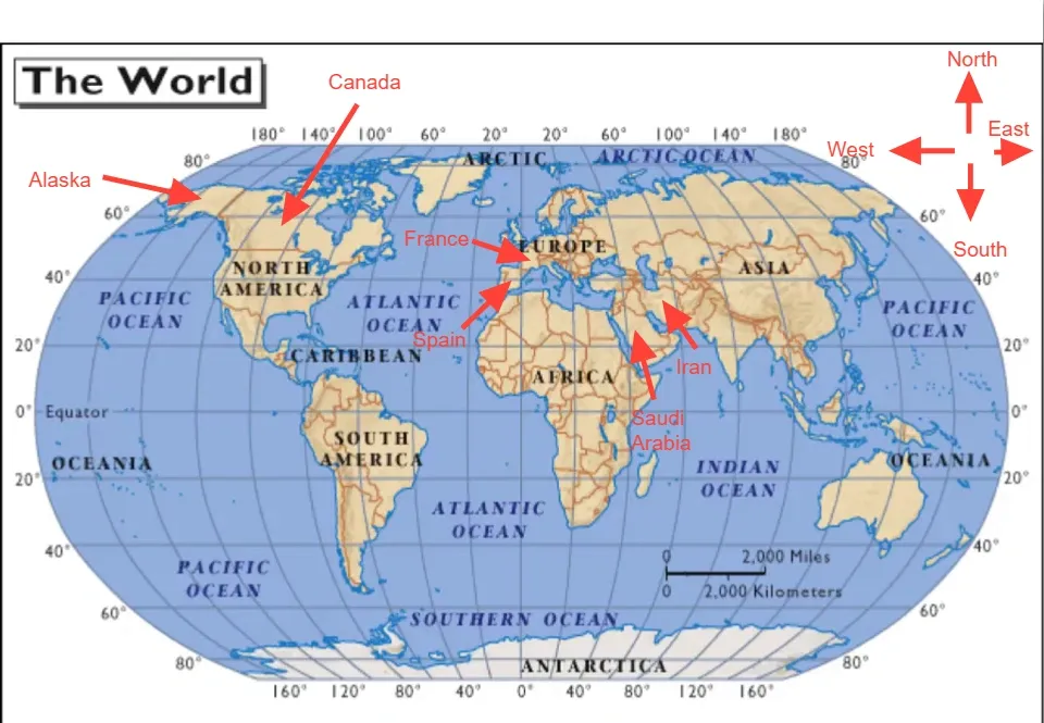
Image Source: Mapscaping.com
Location leads the pack among geography’s five themes and sets the stage for all geographic questions. Learning where something exists makes it possible to understand its importance and how it connects to other places.
Understanding Location
Geographic literacy starts with a simple question: “Where is it?” This basic question reveals two different ways to think about Earth’s surface positions.
What is absolute location in geography?
Absolute location pinpoints the exact spot of a place on Earth using specific coordinates or detailed descriptions. Unlike other location descriptions, absolute location stays the same no matter your view or changes around it.
Geographic coordinates, specifically latitude and longitude, offer the most common way to express absolute location. These coordinates create a global grid system that lets us pinpoint any spot on Earth:
- Latitude measures the north-south position from the equator, ranging from 0° at the equator to 90° at both poles. Each degree of latitude represents approximately 69 miles (111 km).
- Longitude measures east-west position in relation to the Prime Meridian, ranging from 0° to 180° east and west. Lines of longitude run north-south.
The United States Capitol’s absolute location sits at 38° 53′ 35″ N, 77° 00′ 32″ W. This translates to 38.89012259750874, -77.00907196001525 in decimal degrees. Egypt’s Great Pyramid of Giza stands at 29.9792° N, 31.1342° E.
Street addresses also show absolute locations. The Capitol’s address, First St SE in Washington, DC 20004: gives another way to specify its exact spot. Both methods point to the same place using fixed points that don’t depend on other locations.
What is relative location in geography?
Relative location describes how a place sits in relation to other landmarks, places, or geographic features. This type of location changes based on your viewpoint and reference point.
The United States sits south of Canada. Yet looking from another angle, it’s north of Venezuela. This shows how relative location changes depending on your reference point.
You can describe relative location several ways:
- Directional relationships: The U.S. Capitol sits due west of the U.S. Supreme Court.
- Distance: New York City lies about 227 miles north of Washington D.C.’s White House.
- Travel time: A six-minute walk southwest from the Russell Senate Office Building takes you to the U.S. Capitol Building via Constitution Avenue.
- Cultural connections: Key West, Florida and Anchorage, Alaska lie 3,999 miles apart, yet their residents speak English, showing cultural ties despite the distance.
Relative location helps us grasp how places connect. Telling a friend “the restaurant is two blocks north of the park” often works better than giving exact coordinates.
Need help with geography’s five themes? Learn about absolute location, relative location, and physical features.
Why location matters in geography
Location, both absolute and relative: serves as the life-blood of geographic understanding for several reasons.
Accurate navigation and mapping rely on location first. Ancient sailors used celestial navigation, while modern travelers use GPS technology to find their way across the globe. Map makers need absolute locations to create accurate representations of every place.
Human settlement patterns become clear through location analysis. Geographers learn why civilizations grew in certain areas by studying where people live near resources. This shows how water access, fertile soil, and natural resources shape human development.
Location plays a vital role in emergency response. First responders need exact locations to reach people quickly when time matters most. GPS systems have made response times much faster by providing precise coordinates during emergencies.
Location helps us learn about spatial relationships. Understanding both types of location lets geographers study how different places connect and work together. This knowledge helps with:
- Urban planning: Finding the best spots for new developments based on access and nearby infrastructure.
- Economic development: Businesses choose locations near markets, resources, and transportation.
- Migration studies: Tracking exact locations shows how populations move and settle.
- Environmental analysis: Scientists track ecosystem changes and environmental effects over time.
Location provides context to geography’s other four themes. You can’t fully understand place, human-environment interaction, movement, or regions without knowing their location in absolute and relative terms.
Learning about location gives you a powerful tool to analyze the world. From local neighborhood patterns to complex global systems, location builds the foundation for all geographic knowledge.
Exploring Place
Place stands as the second core theme among geography’s five themes. It adds depth and dimension to our understanding of locations. Location tells us where something is, while place tells us what’s there and why it matters.
Learning About Place
The moment you spot a location on Earth, you start to discover its unique character and identity. Place carries many definitions, from “a space or location with meaning” to “an area having unique physical and human characteristics interconnected with other places”. This rich concept covers three main parts: location, locale, and a sense of place. Locale refers to the physical setting where people build relationships. A sense of place describes the emotions people connect to an area based on their experiences.
What are physical features in geography?
Physical features make up Earth’s natural surface characteristics that exist without human activity. These features would stay even if humans vanished, creating the natural foundation where human societies grow.
The most prominent physical features include:
- Major landforms: Mountains, hills, plateaus, and plains that form the simple structure of Earth’s surface
- Bodies of water: Oceans, seas, lakes, and rivers that cover approximately 71% of the planet
- Climate patterns: Temperature, precipitation, and seasonal variations that characterize different regions
- Natural vegetation: Forests, grasslands, deserts, and other plant communities that naturally occur in an area
- Soil composition: The type and quality of soil that influences what can grow in a region
Mount Everest towers at 8,848 meters as Earth’s highest mountain above sea level. The Yarlung Tsangpo Grand Canyon in Tibet plunges 5,500 meters deep, making it one of the world’s most impressive natural formations.
Physical features shape human activities significantly. Fertile plains draw agricultural development. Access to water bodies makes drinking, irrigation, and transportation easier, which leads to settlements in these areas. Harsh environments like deserts or high mountains often limit population growth and development because of their challenging conditions.
Human characteristics that define a place
People’s interactions with their environment create human characteristics. These characteristics cover everything people create or change:
- Built environments: Buildings, roads, bridges, parks, and other structures that change the natural landscape
- Cultural elements: Languages, religions, traditions, and stories tied to specific locations
- Social patterns: Community organization and interaction within a space
- Economic activities: Industries, trades, and livelihoods that develop from available resources
- Historical context: Events and developments that shape a location’s identity through time
Places become meaningful when they gain importance through familiarity or uniqueness. A location becomes a place once someone connects it with distinctive landmarks or personal experiences. This creates what geographers call a “sense of place” the emotional attachment people build with their surroundings.
Each person’s sense of place differs greatly. Different people might think about the same location, but their emotional connections and views could vary based on their experiences there. To name just one example, a neighborhood park might bring happy memories to someone who played there as a child, yet cause discomfort for someone who faced bullying in that same space.
How place influences culture and lifestyle
A place’s physical and human aspects deeply affect how people live, behave, and understand themselves. This shows up in several ways:
Places help form self-identity. Dixon and Durrheim point out that places aren’t just backgrounds for life they become part of who we are. Place identity has four vital parts: deep familiarity from living in physical environments, emotional belonging, symbolic meanings related to self, and the ability to achieve identity-relevant projects.
Natural landscapes spark cultural expressions. Throughout history, artists have drawn inspiration from their surroundings. Religious texts show geographic influences, Buddhist teachings mention lotus flowers common in Asia, while Biblical stories talk about donkeys and dust found in Middle Eastern landscapes.
Local resources create dietary traditions and cuisine. Food shows how geography affects culture clearly, with climate, terrain, and trade routes shaping ingredients and cooking methods. South East Asia’s predictable hot climate and yearly monsoon season make it perfect for growing jasmine rice something impossible in different climates like the UK.
Places shape education and knowledge. People in areas with natural disasters usually learn specific skills related to those threats. Coastal regions that might face tsunamis often teach awareness in their schools.
The quality of place boosts quality of life significantly. Recent Eurobarometer surveys show that quality of life associates with cultural facilities and heritage. These elements propel development and tourism while supporting residents’ wellbeing.
Places change constantly through globalization, population shifts, and new technology. New ideas and technologies transform places as their physical settings and cultures adapt. This dynamic relationship means place continues to affect culture even as culture changes place, creating an ongoing cycle of mutual transformation.
This second theme of geography helps us understand how humans interact with their environment which leads us to the third theme: human-environment interaction.
Human-Environment Interaction
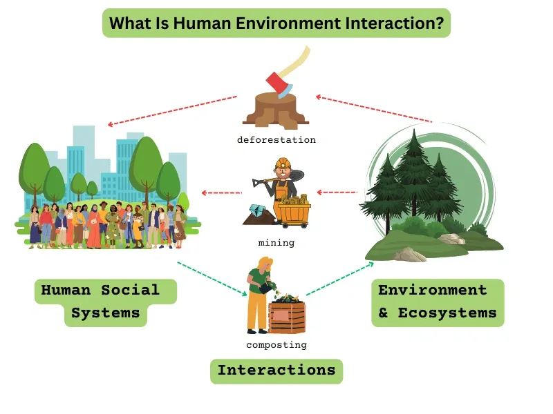
Image Source: GreenCitizen
People and their surroundings share a complex relationship that makes up the third key theme in our look at the five themes of geography. This theme shows how we adapt to our environment, change landscapes to suit our needs, and leave our mark on the natural world. Our relationship with Earth has grown from basic survival tactics to complex changes that have changed Earth’s systems forever.
How humans adapt to their environment
The human body can adapt to many different environments through genetic and physical changes. These changes can happen right away, like quick reflexes, or take place over a lifetime. Some even span multiple generations.
When environmental pressures stay the same for many generations, genetic adaptations emerge. The Inuit people of Greenland, to name just one example, have developed special genetic traits that help them process their traditional diet high in fish and marine mammals. Their bodies decrease the production of long-chain PUFAs and build up short-chain PUFAs that usually come from vegetables. People in Northeast Siberia show similar traits in their CPT1A gene, which helps them process high-fat arctic diets.
Your body can adjust quickly to sudden changes in the environment. When you step out of an air-conditioned building into 90-degree heat, you start sweating right away to keep your temperature stable. Once it gets cooler, the sweating stops.
Changes that happen while you grow up can last your whole life. People born in the mountains usually develop bigger lungs than those who move there as adults. This helps them deal with less oxygen at high altitudes where air pressure is lower. Different mountain populations have found unique ways to adapt:
- Tibetans keep lower hemoglobin levels than expected at high altitudes, with genetic changes in the HIF pathway (especially EPAS1 and EGLN1)
- Ethiopian Amhara show similar traits, likely because of changes in the BHLHE41 gene
- Andean people have developed different ways to adapt than Tibetans and Ethiopians
Culture gives us another powerful way to adapt. We can overcome environmental challenges through knowledge, tools, and behaviors instead of biological changes. These adaptations can happen anytime, from putting on a warm coat to building complex heating systems. Modern humans have conquered extreme environments “largely through technological innovations including fire, clothing, dwellings, advances in hunting equipment and practices, and methods for food and water storage”.
Some cultural adaptations blur the line between learned behavior and biological change. Southeast Asia’s Sea Nomads have built their lives around deep diving, often going deeper than 100 feet for several minutes. Scientists found that Indonesia’s Bajau people have developed larger spleens that squeeze during dives, giving them extra oxygen through released red blood cells.
Ways people modify the land
We don’t just adapt to our environment—we reshape it. Humans now change Earth’s surface more than any other force, moving earth and changing landscapes in many ways.
Farming stands as one of our oldest and biggest ways of changing the land. It covers a third of Earth’s land and uses three-quarters of our limited freshwater. Regular farming methods often harm ecosystems by:
- Causing soil erosion we lose 68 billion tons of topsoil every year, which happens 100 times faster than nature can replace it
- Creating dead zones in water bodies from fertilizer runoff, like the yearly summer problem in the Gulf of Mexico
- Using single-crop farming that reduces plant and animal variety and makes crops more vulnerable to disease
Cities keep growing and taking up more space. The world’s biggest cities leave less room for plants and animals. This growth brings more pollution and puts pressure on water supplies. In spite of that, some cities now use smart planning to add natural spaces, creating a better balance.
Getting resources for energy and materials changes landscapes drastically. Mining, new infrastructure, and urban growth move huge amounts of earth. We’ve changed more than half of Earth’s land surface, and human activities likely affect 83% of ice-free land.
Examples of environmental impact
Human activities affect natural systems more than ever before. Earth’s complex systems keep all life going, but growing populations and new technologies put more pressure on these systems. Since the 1970s, we’ve used more than Earth can restore, and more than 80% of people live in countries that use too many resources.
Climate change might be our biggest impact on the environment. Our modern industrial activities have pushed atmospheric carbon dioxide levels up by almost 50% since 1750. The Intergovernmental Panel on Climate Change states clearly that humans caused this increase in CO2 and other greenhouse gasses.
We’ve also caused massive losses in biodiversity. Human civilization has wiped out 83% of wild mammals and half of all plants. The chickens we raise now weigh three times more than all wild birds combined, while our cattle and pigs outweigh all wild mammals 14 to 1. Losing and splitting up habitats mostly because of farming, threatens 85% of species on the IUCN’s Red List of endangered species.
Our point of view about human-environment interaction has changed over time. Earlier geographers believed our environment determined who we are and what we can do. More recently, researchers have moved toward the idea that while environments might limit some actions, people can still change their surroundings significantly. This shows we better understand human power in environmental relationships, even as we recognize nature’s limits.
This third theme of geography helps explain why different societies develop differently across landscapes. It shows how environments shape what humans can do and how human choices transform environments, sometimes with collateral damage.
Movement Across the Globe
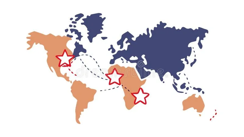
Image Source: Dreamstime.com
Movement stands as the fourth fundamental theme among geography’s five themes. It acts as the dynamic force that connects locations, shapes places, and transforms environments. This theme explores how people, goods, and ideas travel across Earth’s surface. These movements create connections between distant locations and influence cultures worldwide.
People and migration patterns
People have always been on the move throughout history, but modern migration has reached new heights. Today, 281 million international migrants live outside their birth countries. The number of displaced people hit a record high of 117 million by late 2022. Women make up about 48% of all international migrants.
People move for many reasons, creating complex migration patterns. Some look for work or better economic opportunities. Others want to join family members or get an education. Many have no choice but to flee from conflict, persecution, or human rights violations. Climate change now drives more people to move as environmental conditions get worse in vulnerable areas.
This human movement has huge economic effects. Money sent by migrants to their home countries – international remittances – grew by 650% from 2000 to 2022. The amount jumped from $128 billion to $831 billion. Low and middle-income countries received $647 billion of that total. These funds often make up much of their GDPs and exceed foreign direct investment.
Population changes create new migration patterns. Rich nations have aging populations and fewer births. Poor countries maintain higher birth rates. So, future migration might be driven more by wealthy countries competing to attract skilled workers from a shrinking talent pool.
Goods and trade routes
Trade routes have served as global commerce’s lifeline for thousands of years. These routes help exchange goods across big distances. The desire for products from faraway lands has driven the rise of complex international trade networks for more than 8,000 years.
The Silk Road once connected China to the Mediterranean. It enabled trade in silk, spices, and precious metals. The Spice Route linked India and Southeast Asia with Europe. The Indian Ocean Trade network joined East Africa, the Arabian Peninsula, India, and Southeast Asia.
Today’s global trade flows through sea lanes, air routes, and digital networks. Major pathways include:
- The Panama Canal that shortens Atlantic-Pacific Ocean shipping
- The Suez Canal that provides a vital shortcut between Mediterranean and Red Sea
- The Malacca Strait that connects Pacific and Indian Oceans
- The Asia-Europe Route that ranks among world’s longest and most vital trade corridors
Advanced technology has revolutionized goods movement. The container revolution started in 1956 and cut shipping costs dramatically. Loading and unloading at ports used to factor in between 50% and 70% of break-bulk shipping costs. The first container ship sailed from New York to Houston that year. By 1966, Sea-Land Company launched the first regular maritime container line across the Atlantic.
Air freight became economically vital in the 1980s. Digital technologies now reshape all transportation systems through integration with information technologies. Experts call this the digitalization of mobility.
Ideas and cultural diffusion
The movement of people and goods brings along ideas, knowledge, and cultural practices. Geographers call this process cultural diffusion. It happens when one culture adopts elements from another through various ways.
Globalization makes cultural diffusion stronger. Studies show that the spread of knowledge and technology across borders has intensified because of globalization. This speeds up in two main ways:
- Foreign knowledge becomes easier to access
- International competition pushes firms to invent and adopt foreign technologies
This affects emerging market economies significantly. These countries now use available foreign knowledge to boost innovation and improve worker productivity. Knowledge flows from technology leaders generated about 0.7 percentage points of labor productivity growth per year for an average country-sector from 2004-2014. This represents roughly 40% of observed average productivity growth in that period.
People carry their languages, religions, foods, and customs when they move. This makes migration a powerful tool for cultural exchange. Trade networks speed up this process too. Merchants historically shared not just goods but also new technologies, philosophies, and religious beliefs.
The internet has changed cultural diffusion completely. Many consider it the biggest cultural exchange in human history. Unlike old trade routes, the internet reaches beyond geographical limits. Ideas and information flow instantly worldwide.
Technology leaders themselves benefit from each other’s state-of-the-art developments. This shows that as countries like China and Korea contribute more to expanding technology frontiers, new inventors might help traditional ones. This creates an ongoing cycle of knowledge exchange.
This fourth theme of geography reveals how our connected world works. The constant flow of people, goods, and ideas across borders shapes both local communities and global systems.
Defining Regions
Regions represent the last of the five themes of geography. These analytical tools help geographers make sense of Earth’s complex spatial patterns. A region is an area characterized by specific shared features that sets it apart from others through physical, cultural, economic, or political characteristics.
Formal, functional, and perceptual regions
Geographers break down regions into three categories based on their definitions. Formal regions (also known as uniform or homogeneous regions) have clear boundaries and specific traits that run throughout the area. These areas come with officially defined borders that everyone agrees on. Countries, states, climate zones, and language regions serve as good examples.
Functional regions revolve around a central point where surrounding areas connect through shared activities. These regions differ from formal ones because connections and interactions define them to serve specific purposes. A metropolitan area shows this concept well, the city serves as the core while suburbs connect through daily commutes, economic bonds, and service areas.
Perceptual regions (also called vernacular regions) exist in people’s minds based on their views and feelings about places. You won’t find exact boundaries here, and different people or cultures might see them differently. The “Deep South” or “Midwest” in the United States shows this perfectly, people draw different boundaries based on their personal views.
How regions help us understand the world
Regionalization is a vital part of geography that helps sort complex information about areas into manageable groups. This approach helps you understand social, economic, and environmental problems in specific contexts. We group and analyze spatial patterns by looking at common characteristics.
Regional analysis shows how human activities shape and are shaped by the physical environment. Geographers can spot patterns in land use, resource management, and environmental changes that might be hard to recognize otherwise.
Examples of regions in daily life
You deal with regional concepts more often than you might think. Looking for a new home? You’re basically using a personal Geographic Information System. Your brain overlays mental maps of physical features with social and economic aspects to find the perfect spot.
The way you understand your neighborhood shows regional thinking at work. Learning safe areas and places to avoid means understanding location, local features, and how things cluster together, these are the foundations of geographic concepts. Here are some everyday examples:
- School districts (formal regions with set boundaries)
- Pizza delivery ranges (functional regions with restaurants at the center)
- “Silicon Valley” (a perceptual region without exact borders but known for tech)
Understanding regions helps businesses, governments, and organizations make smart decisions about policies, investments, and development.
Conclusion
The five themes of geography will change how you see the world around you. This piece has shown how these connected concepts help simplify complex geographic information. Location serves as the starting point and answers the vital “where” question through exact coordinates and relative descriptions. Place adds another layer by showing what makes each location special through its physical and human features.
People’s relationship with their environment shows how we adapt to and change natural systems. Movement links everything as people, goods, and ideas flow across Earth, which creates our connected global community. Regions organize geographic details into useful groups based on common traits, boundaries, connections, or how people perceive them.
These five themes give you powerful tools to analyze geography. You can use them to make sense of everything from local neighborhoods to worldwide systems. Next time you travel, watch news, or explore your area, look for these themes in action. You’ll see how location shapes place, how people change their environment, how movement builds connections, and how regions help us understand it all.
Geography is part of our daily lives, even when we don’t notice it. These five themes give you the tools to better understand the world. This knowledge helps students with homework, professionals who make location-based choices, and anyone who wants to understand our connected planet better.